
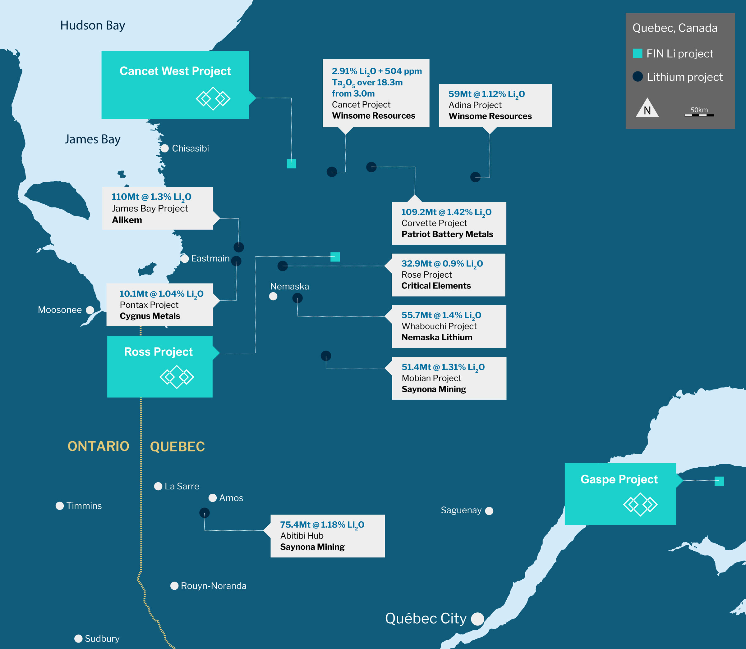
Mt Tremblant Lithium Projects, Quebec, Canada
Mt Tremblant Lithium Projects
- 100% owned projects cover a combined 190km2 across underexplored, highly prospective areas in James Bay, Quebec
- Tier 1, established mining jurisdiction presenting low-risk, supportive government and eligibility to significant tax incentives
- Quality Infrastructure ~13km from all-weather road access; ~15km from existing Hydropower lines; ~50kms from Hydropower
Cancet West Lithium Project | White Bear Lithium Discovery
- Exceptionally high-grade lithium results (6.85% Li2O & 6.50% Li2O) and upcoming drill programme
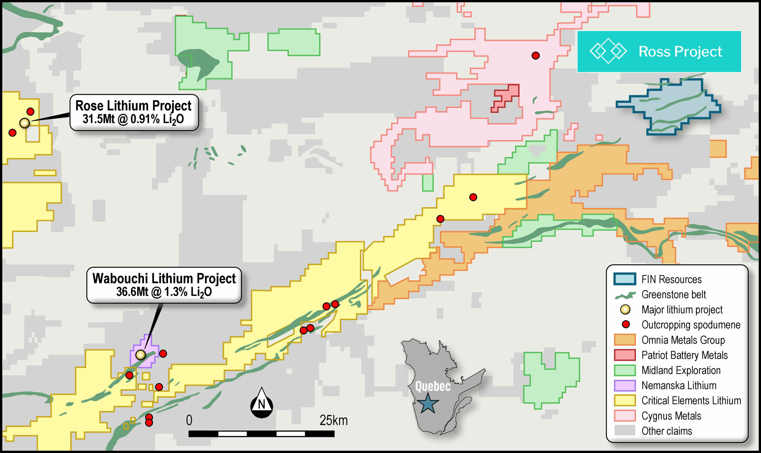
Ross Lithium Project
- +30km strike length underexplored greenstone belt located along strike to the east of the neighbouring Whabouchi lithium deposit (55.7 Mt at 1.4% Li2O)
Gaspe Lithium Project
- Potential to host lithium in clay mineralisation
Figure 1: James Bay regional map , Quebec , Canada
Cancet West Lithium Project | White Bear Lithium Discovery
Cancet West Lithium Project | White Bear Lithium Discovery
- Located in the prolific James Bay area in Quebec, Canada
- Cancet West Lithium Project ~80km2
The project’s claims are centred on +15 km of prospective greenstone strike length of the Guyer greenstone belt located within the La Grande Subprovince of the Archean Superior Province.
Figure 2: Cancet West Lithium Project location
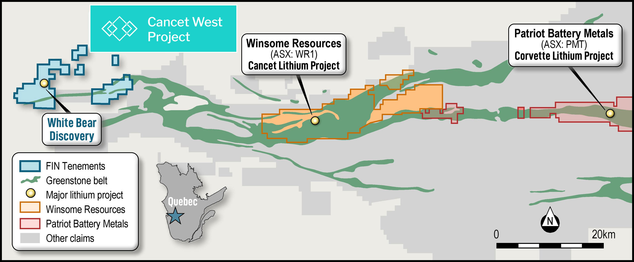
- Exceptionally high-grade lithium results (6.85% Li2O & 6.50% Li2O) in coarse spodumene bearing pegmatite. +15km strike length of the Archean-aged Lac Guyer greenstone belt, host to projects which have outstanding drill success:
- Patriot Battery Metals (ASX: PMT) Corvette Project recently announced lithium results, including 156.9m at 2.12% Li2O and 159.7m at 1.65% Li2O; and
- Winsome Resources Limited (ASX:WR1) Cancet Project recently identifying additional targets at the project area with the potential to significantly increase lithium tonnage
- Logistics and approvals process underway for an aggressive fully funded drilling programme in Q1 2024
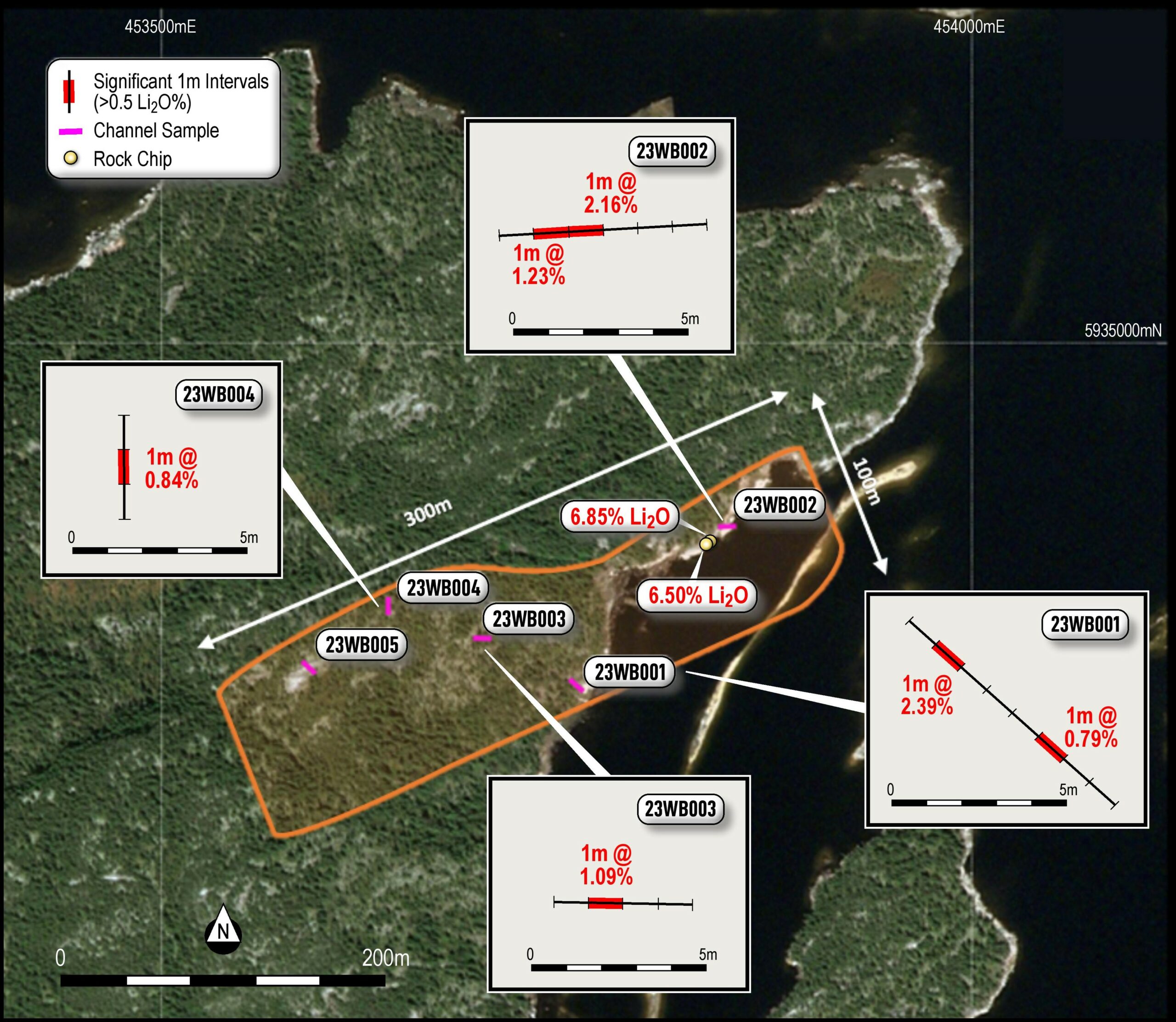
- In total, 5 insitu pegmatite outcrops have been mapped at the White Bear Lithium Discovery within the spodumene-bearing zone, commonly hosting crystals of beryl, orange garnets and pockets of coarse quartz, in addition to green spodumene
- Channel sampled outcrops successfully returned high grade surface Li2O) within coarse spodumene mineralisation:
- 23WB001 – 1m @ 2.39% Li2O
- 23WB002 – 1m @ 2.16% Li2O and 1m at 1.23%
- 23WB003 – 1m @ 1.09% Li2O
- 23WB004 – 1m @ 0.84% Li2O
- Coarse (≤70cm), spodumene-bearing high-grade lithium mineralised zone,identified over ~300m strike length by 100m at its widestwithin five pegmatite outcrops
- Elevated Cs (Max 1,284ppm) and Ta2O5 (Max 217ppm) also reported
Figure 3: Additional claims at the Cancet West Lithium Project and Location of Confirmed Spodumene
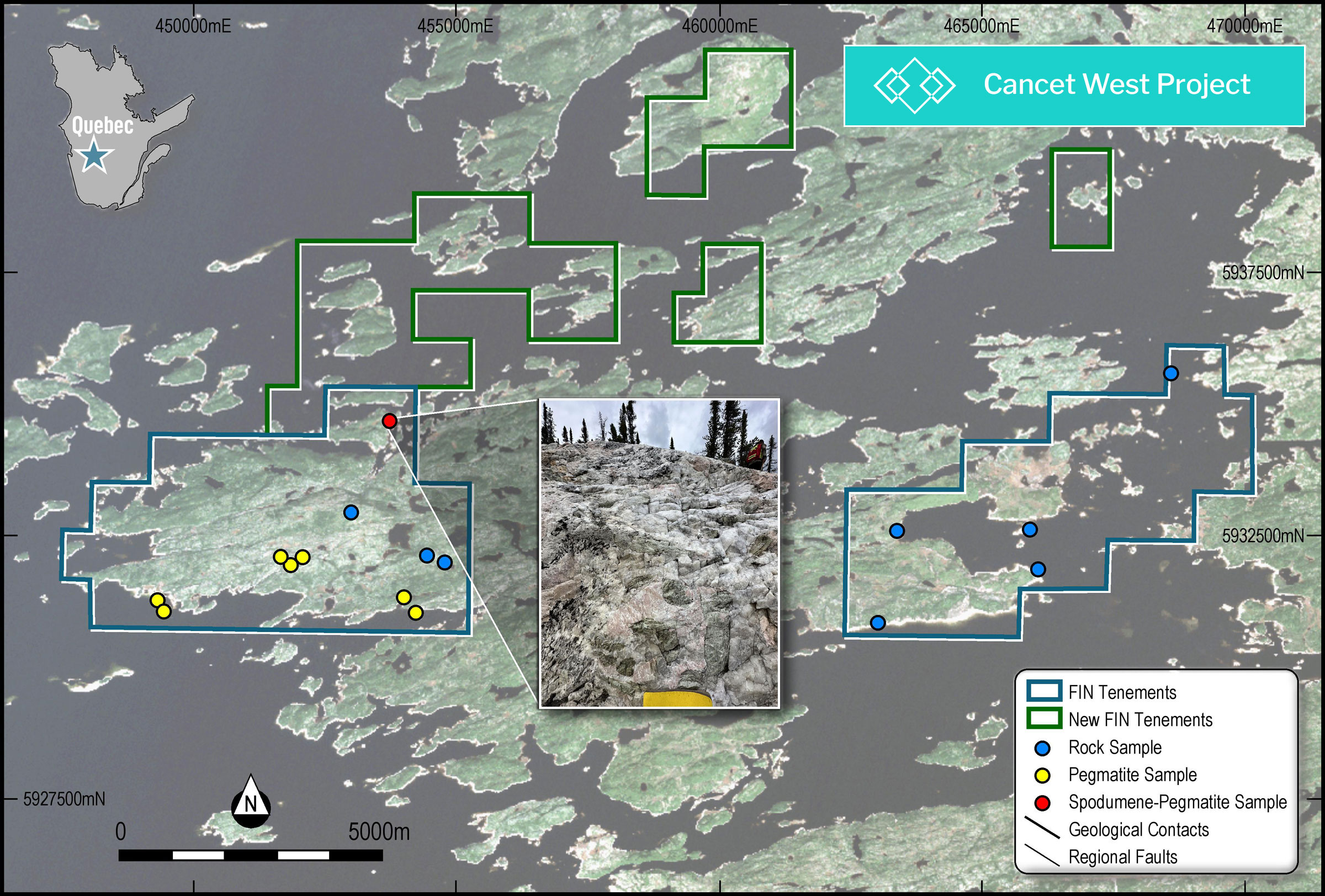
Figure 4: Map showing channel sample locations and significant results across the White Bear Lithium Discovery
Maiden fieldwork programmes identify Lithium mineralisation in coarse spodumene bearing zone within pegmatite outcrops trending northeast to southwest and truncated by a regional north-northeast to south-southwest striking shear zone.
Pegmatite bodies are likely to extend for significant distances, along strike under cover and down dip. In addition to high-grade Li2O, strong relationship between anomalous lithium and potassium/rubidium ratios (K/Rb<35), suggest that the system at White Bear is likely to be highly fractionated and lithium fertile.
An application has been submitted for approval of an aggressive 5,000m diamond drilling programme via the QC government and Hydro Quebec ~10-15km strike length of the Archean-aged Lac Guyer greenstone belt and prospective deformation zone remains to be explored.
Figure 5: Large green spodumene crystal at Cancet West
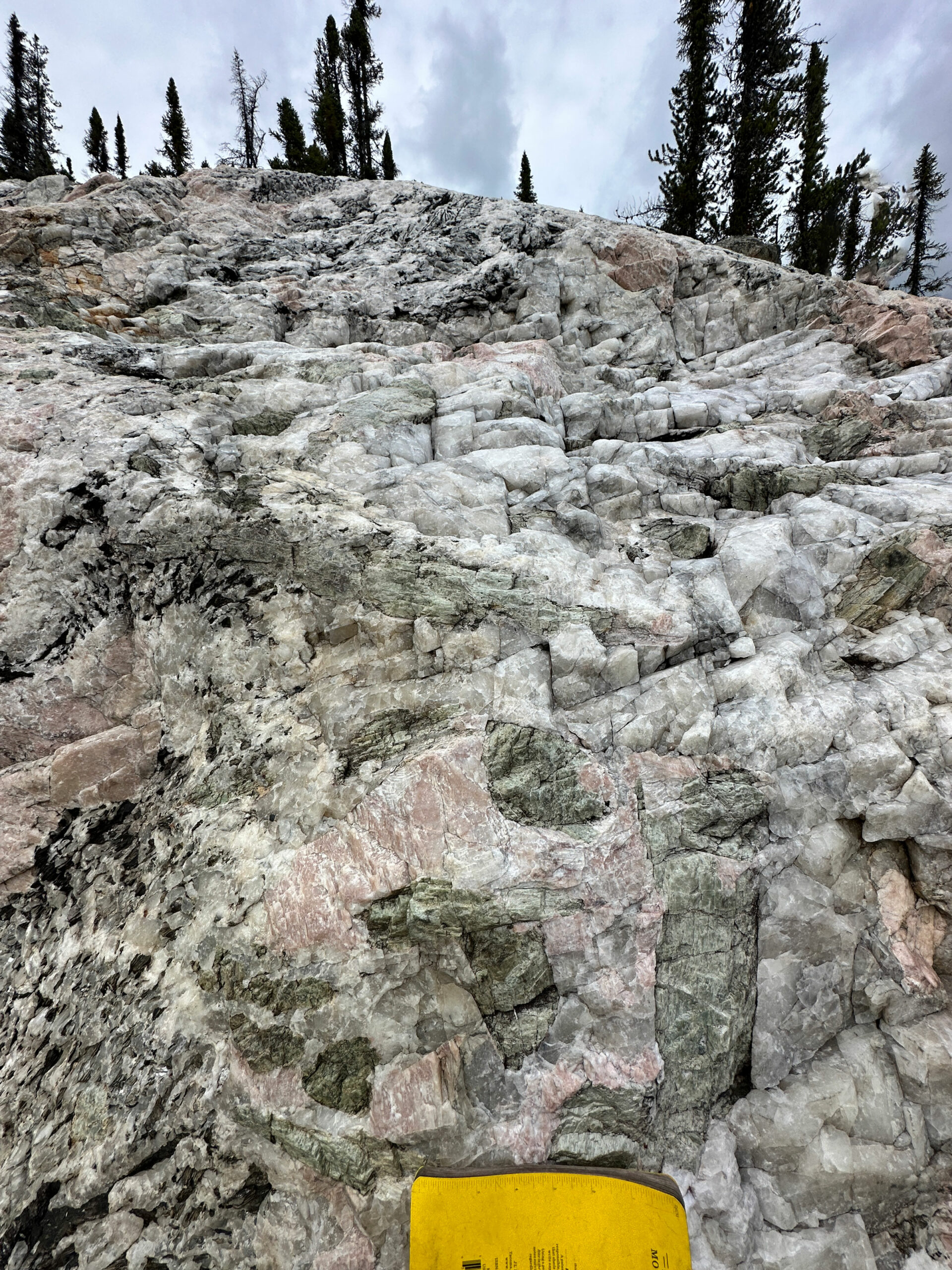
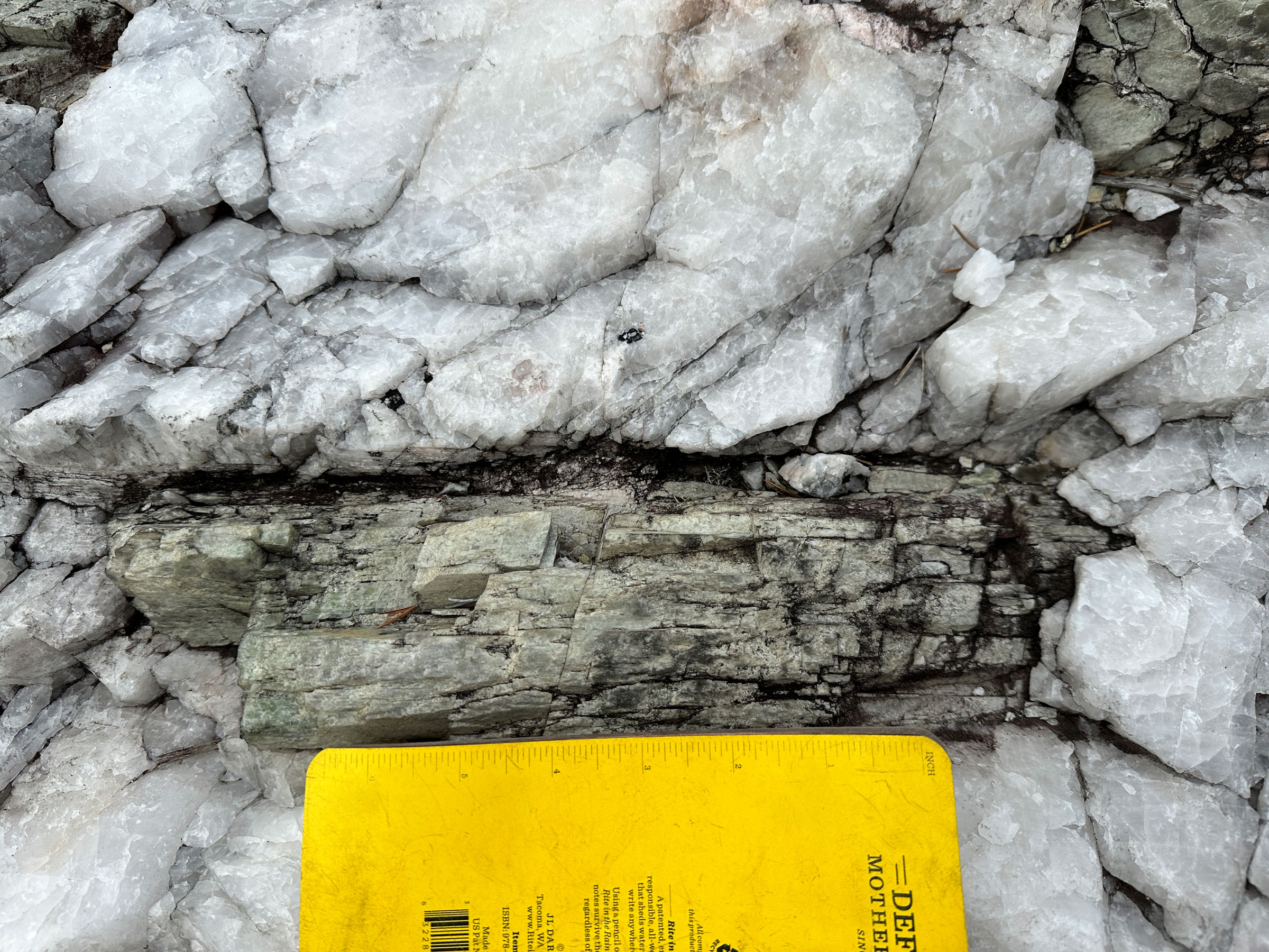
Figure 6: Green spodumene crystal within Pegmatite outcrop at Cancet West
Ross Lithium Project
Ross Lithium Project
Greenstone belt multiple mapped pegmatite occurrences underexplored
The Ross Lithium Project is comprised of 86km2 of minerals claims located approximately 90 kilometres northeast of Nemaska Whabouchi spodumene-bearing pegmatites lithium deposit (proven resource 36.6Mt @ 1.3% Li2O).
- The Whabouchi Lithium deposit is hosted within northeast-southwest striking greenstones that extend to the northeast through the Ross Lithium Project
- The Ross project covers more than 30km underexplored greenstone, highly prospective to host pegmatites within the Project area.
- Discovery of at least 5 pegmatite bodies during maiden fieldwork program with one area hosting multiple outcrops and a large pegmatite boulder field with a strike length of 200m-300m
Figure 7: Ross Lithium Project location
Large megacrystic feldspars, coarse muscovite, quartz and fine red garnets mapped across a number of the pegmatite float and outcrops sighted with elevated TREO reported
- In total, 5 insitu megacrystic pegmatite bodies with feldspar crystals up to 20cm in diameter were mapped within host amphibolite or granite
- The presence of pockets of fine-grained red garnets within at least two of the pegmatite bodies may indicate an evolved pegmatite system which could be related to the emplacement of an LCT pegmatite
- A total of 9 outcrop and 1 float grab samples were collected during initial two-day field visit
- No anomalous lithium values were returned however elevated TREO values have been reported and will be follow up during the 2024 field season
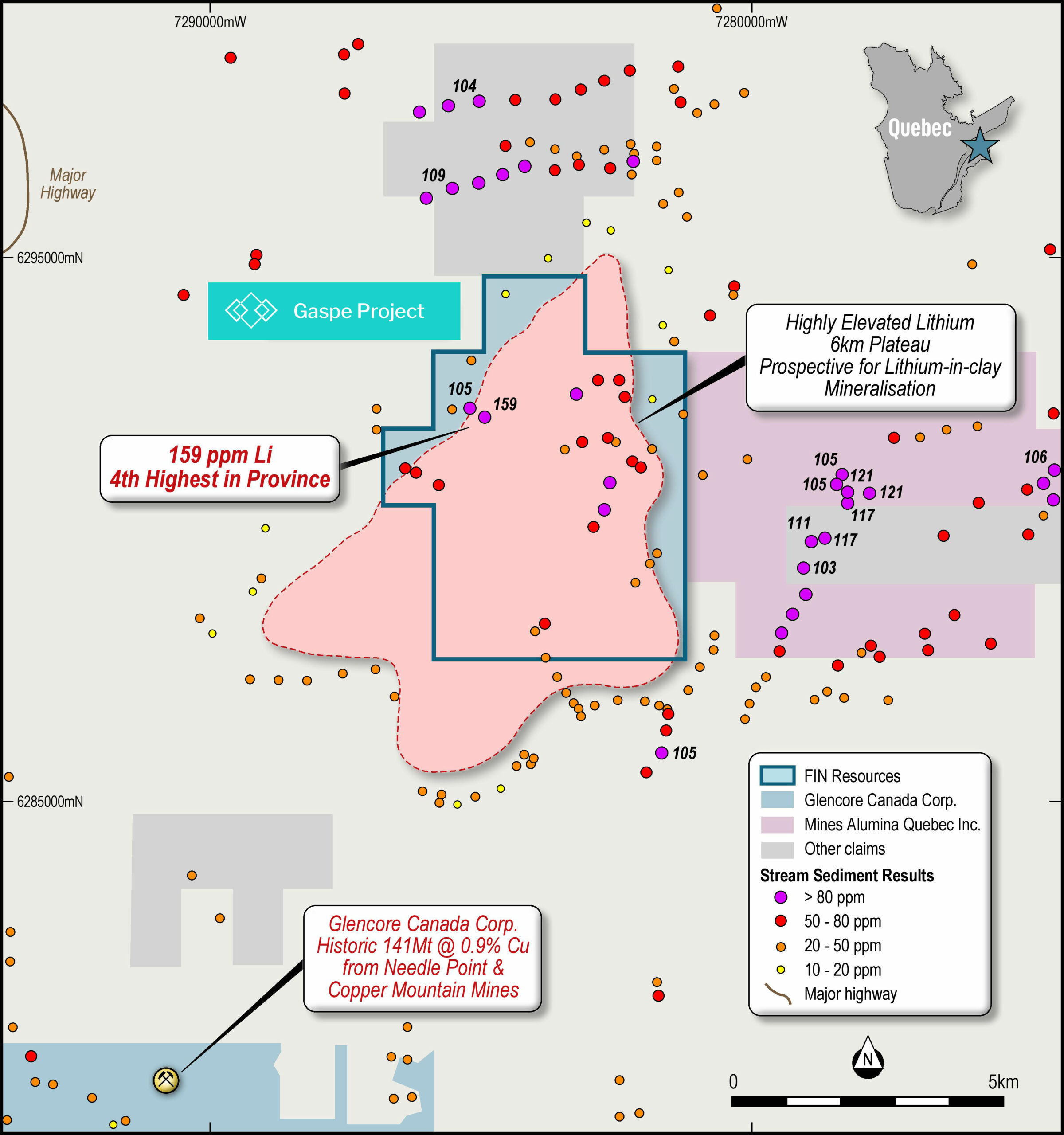
Gaspe Lithium Project
Gaspe Lithium Project
The Gaspe Lithium Project, which covers a total are of 13.1km2 is located within the Gaspe Peninsula in southeast Quebec. The Company believes that the Gaspe Project has the potential to host a lithium in clay deposit with the project located within an east-west sedimentary (mudstone) belt, that contains several regional scaled faults within or near the property.
The project is centred around a zone of anomalous Lithium in soil samples within regional datasets. Further interpretation and analyses of these datasets is underway.
- Total project area of 13.1km2 centred around a zone of anomalous lithium-in-soil samples within regional datasets
- Centered around a promontory drained by several streams where sampling program returned extremely elevated lithium-in-stream sediment results incl:
- 342ppm Li2O (159ppm Li) = the 4th highest result in Quebec nationwide database
- ~550,000 sample Quebec-wide database, with 85 individual sample points returning >100ppm Li and only 5 >150ppm hinting at the prospectivity of Gaspe Lithium Project
- Several stream sediment samples returning elevated tantalum (Ta; max 44ppm), caesium (Ce; max 149ppm) and tungsten (W; max 118ppm)
- Sample 1992012610 located in the northeast reported anomalous Au (145ppb), Ag (41ppm), Cr (577ppm), Nb (292ppm), V (300.5ppm), Y (102ppm) and Zr (2,465ppm)
- Located within an east-west trending sedimentary (mudstone) belt associated with extremely high lithium-in-silt sample results and several major regional faults intersect within or near to the project area
- Further interpretation and analyses of these datasets is underway.
Figure 8: Gaspe Project with Lithium Stream Sediment Results